Future Perfect
How do you imagine Cache Valley, home of Utah State University, in about 20 years? Do you envision wide open spaces with pastoral scenes of cattle, mountains and wildlife or miles of strip malls, subdivisions and big box stores?
USU graduate student researchers in the Department of Environment and Society’s Bioregional Planning Program set out last fall to explore varied growth scenarios and provide community planners with some “what if” tools to contemplate the valley’s future direction.
Efforts by Kent Braddy, Kevin Campbell, Jordy Guth, Ellie Leydsman, Jay T. Price, Brandon Taro and the late Lynne Slade were rewarded this past month when their report “Cache Valley 2030—The Future Explored” was selected for the 2006 Award of Merit for Plan Development from the Utah chapter of the American Planning Association.
Slade, who was employed with the university as an advisor in the College of Humanities, Arts and Social Sciences, passed away May 18, 2006. The studio team dedicated the report, which was completed in June 2006, to her memory.
This is the third year in a row that the APA Chapter has selected a bioregional planning study from USU’s College of Natural Resources for a professional award.
The impetus for the students’ Cache Valley 2030 project emerged from an interdisciplinary forum of local community planners and citizens, which spawned a regional commission to help unify planning for local governments and communities. The project is intended to provide a foundation for the commission’s future efforts.
For the project, student researchers spent hours poring over county reports and surveys and traveling around the valley on foot, by car and in small aircraft to make site assessments and compile background research for the report. They then created a series of map models using GIS data to provide a foundation for developing selected alternative futures and to provide models for measuring the potential impact of each future.
The studio project was designed and directed by professor Richard Toth as part of the student learning experience in bioregional planning. “When we first took on the project, we were uncertain of how to start,” says Leydsman. “We could have done a million things but with limited time and resources, we had to focus our efforts. Prof. Toth advised us on how to make the best of the data that was already available and gave us some valuable suggestions on how to target our research.”
Among the assessment models the group developed for the project were public health, safety and welfare, and critical lands which pinpoints such hazards as floodplains, steep slopes, fault zones, areas susceptible to soil liquefaction and wildland-urban interface; surface water, ground water, visibility assessment and Cache Valley identity.
What researchers gleaned from public surveys, says Leydsman, is that the majority of valley residents want to preserve the valley’s natural and agricultural vistas and the community’s “small town” feel. Yet current development trends counter those preferences.
“Currently, people are building without giving much thought to the overall impact of their choices,” says Braddy.
The researchers developed eight “alternative futures” for growth and, using the assessment models, demonstrated the impact of each. A planner, for example, might want residential development on a particular site, but this might result in homes being built on floodplains and wetlands causing the loss of critical wildlife habitat. This same development might also impact the valley’s visual quality – that is, mountain and valley views – including the valley’s unique historic characteristics.
“The assessment models allow you to view the potential impact of varied decisions,” says Braddy. Planning is critical, he says, because Cache Valley’s population is expected to double by the year 2030.
“The valley is changing and will continue to change, whether we like it or not. The question is, are we willing to take steps to plan for the course of future growth?” says Leydsman.
“We’re extremely proud of these students,” says Terry Sharik, head of the Environment and Society Department in USU’s College of Natural Resources, who adds that the department’s Bioregional Planning Program is very unique and provides significant benefits to state and local governments. Graduates of the program are employed in state, county and municipal planning offices throughout the region.
To view the full report, visit the Cache Valley 2030 Web site.
Related Links
- USU Department of Environment and Society
- USU Graduate Program in Bioregional Planning
- Growing Smarter
- USU College of Natural Resources
Contact: Richard E. Toth, 435-797-0694, rtoth@cc.usu.edu
Writer: Mary-Ann Muffoletto, 435-797-1429, maryann.muffoletto@usu.edu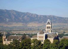
USU graduate bioregional planning students crafted an exhaustive report to examine Cache Valley's future. Photo by Ellie Leydsman.
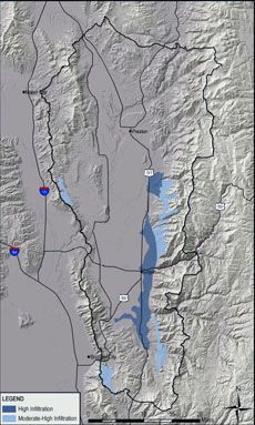
The report features varied assessment models that identify ground water and wetlands and pinpoint such hazards as areas susceptible to soil liquefaction, floodplains, fault zones and more.

Bioregional planning team members, from left, Jordy Guth, Kent Braddy and Ellie Leydsman, display the 2006 Award of Merit for Plan Development their report, "Cache Valley 2030," received from the Utah Chapter of the American Planning Association.
SHARE
TRANSLATE
Comments and questions regarding this article may be directed to the contact person listed on this page.


